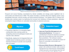
Informal street vending poses challenges related to regulation, food security, and urban planning in Bahamas. This project standardizes vending architecture and creates climate-smart open green market spaces for street vendors, reducing the impact of extreme weather events. The infrastructure uses renewable energy, waste management, and water facilities, improving the livelihoods of vendors while promoting sustainability
Rapid urbanization and a growing population lead to increases in vulnerability to coastal hazards such as floods and storm surges. This project develops a prototype of a Multi-Hazard Platform (MHP) for forecasting climate extremes and physical hazards. It enhances disaster resilience by providing access to localized weather forecasting, hazard mapping, and early warning, with a focus on coastal flood risk.
Frequent and severe flooding, exacerbated by climate variability and change, poses significant risk to communities and infrastructure in Mali. This project develops a real-time flood risk mapping system using precipitation forecasts, remote sensing, and deep learning techniques. The initiative aims to enhance the existing early warning system by improving the accuracy and timeliness of flood predictions, ultimately reducing the impact of floods on vulnerable communities in selected rural area.