Network member
Technology sector
Agriculture
Coastal zones
Early warning and Environmental assessment
Forestry
Marine and Fisheries
Water
Cross-sectoral
Website
Focal point email
Problem
Addressing climate change and building resilience require countries to access, analyze, and apply vast amounts of environmental, social, and economic data. Yet for many governments - especially in Least Developed Countries (LDCs) and Small Island Developing States (SIDS) - this data is fragmented, difficult to access, or locked in formats that are not usable for decision-making. Critical Earth observation (EO) and geospatial datasets are often underutilized due to barriers such as limited technical capacity, weak digital infrastructure, high costs of processing and storage, and the absence of enabling governance frameworks.
Without integrated, user-friendly systems, policymakers and practitioners struggle to translate satellite and other data into actionable insights for coastal management, food security, disaster preparedness, and climate adaptation. The result is a persistent gap between data availability and data use, which undermines the ability of countries to plan, respond, and adapt effectively to climate-related risks.
Without integrated, user-friendly systems, policymakers and practitioners struggle to translate satellite and other data into actionable insights for coastal management, food security, disaster preparedness, and climate adaptation. The result is a persistent gap between data availability and data use, which undermines the ability of countries to plan, respond, and adapt effectively to climate-related risks.
Solution
Digital Earth platforms provide countries with a powerful way to transform complex satellite, geospatial, and environmental datasets into accessible, decision-ready insights. D4DInsights supports governments and partners in designing, deploying, and sustaining Digital Earth systems that are tailored to national and regional priorities.
Our approach combines advanced data infrastructure (including cloud, hybrid, and open-source architectures) with cutting-edge analytics such as machine learning, AI models, and geospatial processing. Beyond the technology, we emphasize the enabling environment - strengthening governance frameworks, building institutional and technical capacity, engaging diverse stakeholders, and aligning with sustainable finance strategies.
Through this holistic model, D4DInsights has helped launch and scale initiatives such as Digital Earth Africa and Digital Earth Pacific, ensuring that countries can monitor coastlines, track land and water resources, assess climate risks, and support disaster preparedness. By embedding capacity development and stakeholder ownership into every stage, our Digital Earth solutions ensure long-term sustainability and empower countries to translate data into policies and actions for climate resilience and sustainable development.
Performance and impacts
Digital Earth platforms have been implemented and operationalized at continental, regional, and national scales, demonstrating proven impact and scalability.
Key performance indicators include:
- Operational Platforms: Digital Earth has been deployed in Australia, across all of Africa, and the Pacific, with country-level implementations in Asia, Latin America, and the Middle East. These platforms provide operational services to governments, researchers, and development partners.
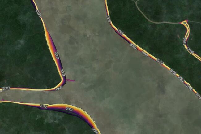
- Product Delivery: Platforms deliver decision-ready products such as coastline change monitoring, satellite-derived bathymetry, water and land use mapping, and agricultural assessments, with measurable uptake by national agencies and regional bodies.
- User Reach: Thousands of users - including government ministries, UN agencies, NGOs, and academic institutions - access Digital Earth products and services, with usage metrics tracked through data portals, dashboards, and APIs.
- Capacity Development: Dedicated training programs and communities of practice have strengthened national and regional expertise, measured through the number of trained practitioners, ongoing user support, and institutional integration.
- Policy and Decision Impact: Evidence of use in climate adaptation planning, disaster risk management, and resource management policies, documented through case studies and country feedback.
- Sustainability: Platforms are designed with open data principles, hybrid cloud/on-premise hosting, and multi-stakeholder governance models, ensuring continuity and cost-effectiveness.
These metrics demonstrate that Digital Earth is not a proof of concept but an operational, scalable, and impactful system, enabling countries to harness geospatial and satellite data for climate resilience and sustainable development.
Key performance indicators include:
- Operational Platforms: Digital Earth has been deployed in Australia, across all of Africa, and the Pacific, with country-level implementations in Asia, Latin America, and the Middle East. These platforms provide operational services to governments, researchers, and development partners.
- Product Delivery: Platforms deliver decision-ready products such as coastline change monitoring, satellite-derived bathymetry, water and land use mapping, and agricultural assessments, with measurable uptake by national agencies and regional bodies.
- User Reach: Thousands of users - including government ministries, UN agencies, NGOs, and academic institutions - access Digital Earth products and services, with usage metrics tracked through data portals, dashboards, and APIs.
- Capacity Development: Dedicated training programs and communities of practice have strengthened national and regional expertise, measured through the number of trained practitioners, ongoing user support, and institutional integration.
- Policy and Decision Impact: Evidence of use in climate adaptation planning, disaster risk management, and resource management policies, documented through case studies and country feedback.
- Sustainability: Platforms are designed with open data principles, hybrid cloud/on-premise hosting, and multi-stakeholder governance models, ensuring continuity and cost-effectiveness.
These metrics demonstrate that Digital Earth is not a proof of concept but an operational, scalable, and impactful system, enabling countries to harness geospatial and satellite data for climate resilience and sustainable development.